| |
|

Price: £ 36.00 + VAT
VAT is charged at 15% for all EU customers.To get an approximate conversion of this price to your currency,
Click Here.
Postage Costs: UK: £5.75 (Guaranteed before 2pm next day. Insured. Signature Reqd.)
Europe: £9.25 (Insured, Signature Reqd. upon delivery)
Order Now Using Secure Credit Card Server
|
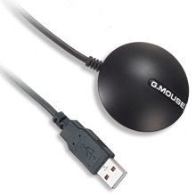
USB GPS RECEIVER, BU-353
GPS Navigation With Your Laptop!
- WAAS enabled for better accuracy
- Small, sleek and stylish design
- USB requires no external power
- Water-resistant housing with magnetic mount
- SiRF Star III low power chipset with V3.1.1 Firmware
- RoHS compliant
|
|
Description:
The BU-353 USB GPS Receiver has improved accuracy by utilizing
WAAS GPS positioning when connected to your laptop's USB
port. Travel positions are updated in real-time on your laptop or
tablet PC with use of your own street mapping software.
BU-353 is totally NMEA-compliant and has the powerful SiRF III low-power
chipset meaning less power to operate than other USB GPS's. Quick cold-start
times of only 42 seconds while enhanced technology also provides improved
tracking in weak signal areas.
The BU-353 is a 20-channel USB GPS receiver which includes a built-in
LED that indicates satellite acquisition status: Flashing RED indicates
searching for satellites, while solid RED indicates satellites are
in view and data is being received.
The BU-353 USB GPS Receiver is designed to plug into most any laptop
PC's USB port without the need of an additional source for power!
Forget dealing with extra batteries, keyboard pass-through cables
or 12VDC cigarette lighter adapters, because power and data are
both transmitted through a single cable connected to the USB port!
The 60" cable with a suction cup clip and the water-resistant
housing with a built-in magnet allows flexibility for in-vehicle
or external placement.
BU-353 USB GPS includes a driver to convert the USB port into a
virtual COM port so it can work with these and most any other NMEA
compliant mapping software on the market today:
|
|
Features:
- SiRF Star-III chipset w/ V3.1.1 Firmware
- WAAS enabled engine board for greater accuracy
- All-in-view 20-channel parallel processing
- Built-in active antenna
- High sensitivity to satellite signal
- Cold start under 42 seconds, average
- Superior urban canyon performance
- FoliageLock for weak signal tracking
- Build-in SuperCap to reserve system data for rapid satellite acquisition.
- Supported NMEA 0183 command: GGA, GSA, GSV, RMC, GLL, VTG
- Super-cohesive magnetic for mounting on the car
- Non-slip on the bottom
- USB interface connection port
- LED indicator for GPS fix:
- LED OFF: GPS receiver is off
- LED FLASHING: No fix, searching for GPS signal
- LED ON: Position fixed, GPS receiving signal
Interface:
USB
Benefits:
PLAN ROUTES AND TRIPS
Use your BU-353 USB GPS on business or pleasure and eliminate the frustration of driving in unknown areas, whether it be across town or across
the country. With the BU-353 USB GPS and your personal mapping software (not included) installed on your laptop, you can chart your travel progress in real-time.
SEE YOUR LOCATION
Need to take a detour? No problem, see your exact position in relation to your planned route to easily get back on track by using GPS technology.
NO SUBSCRIPTION FEE
BU-353 USB GPS requires NO SUBSCRIPTION fees!
|
|
USB GPS Drivers and Guides:
Specifications:
| Electrical Characteristics (Receiver) |
| Frequency |
L1, 1575.42 MHz |
| C/A Code |
1.023 MHz chip rate |
| Channels |
20 |
| Sensitivity |
-159 dBm |
| Accuracy |
| Position Horizontal |
10m 2D RMS (SA off) |
| Velocity |
0.1m/sec 95% (SA off) |
| Time |
1 micro-second synchronized to GPS time |
| Datum |
| Datum |
WGS-84 |
| Acquisition Rate |
| Hot start |
1 sec., average (with ephemeris and almanac valid) |
| Warm start |
38 sec., average (with almanac but not ephemeris) |
| Cold start |
42 sec., average (neither almanac nor ephemeris) |
| Reacquisition |
0.1 sec. average (interruption recovery time) |
| Protocol |
| GPS Protocol |
Default: NMEA 0183 (Secondary: SiRF binary) |
| GPS Output Data |
SiRF binary >> position, velocity, altitude, status and control, NMEA0183 V2.2 protocol,
and supports command: GGA, GSA, GSV, RMC (VTG and GLL are optional). |
| GPS transfer rate |
Software command setting (Default: 4800,n,8,1 for NMEA ) |
| Dynamic Conditions |
| Acceleration Limit |
Less than 4g |
| Altitude Limit |
18,000 meters (60,000 feet) max. |
| Velocity Limit |
515 meters/sec. (1,000 knots) max. |
| Jerk Limit |
20 m/sec**3 |
| Temperature |
| Operating |
-40°~ 85°C (-40°F~ 185°F) |
| Storage |
-40°~ 85°C (-40°F~ 185°F) |
| Humidity |
Up to 95% non-condensing |
| Power |
| Voltage |
4.5v - 6.5v |
| Current |
80mA typical |
| Physical Characteristics |
| Dimension |
53mm diameter. Height 19.2 mm |
| USB Cable Length |
165cm |
|
|
|

